
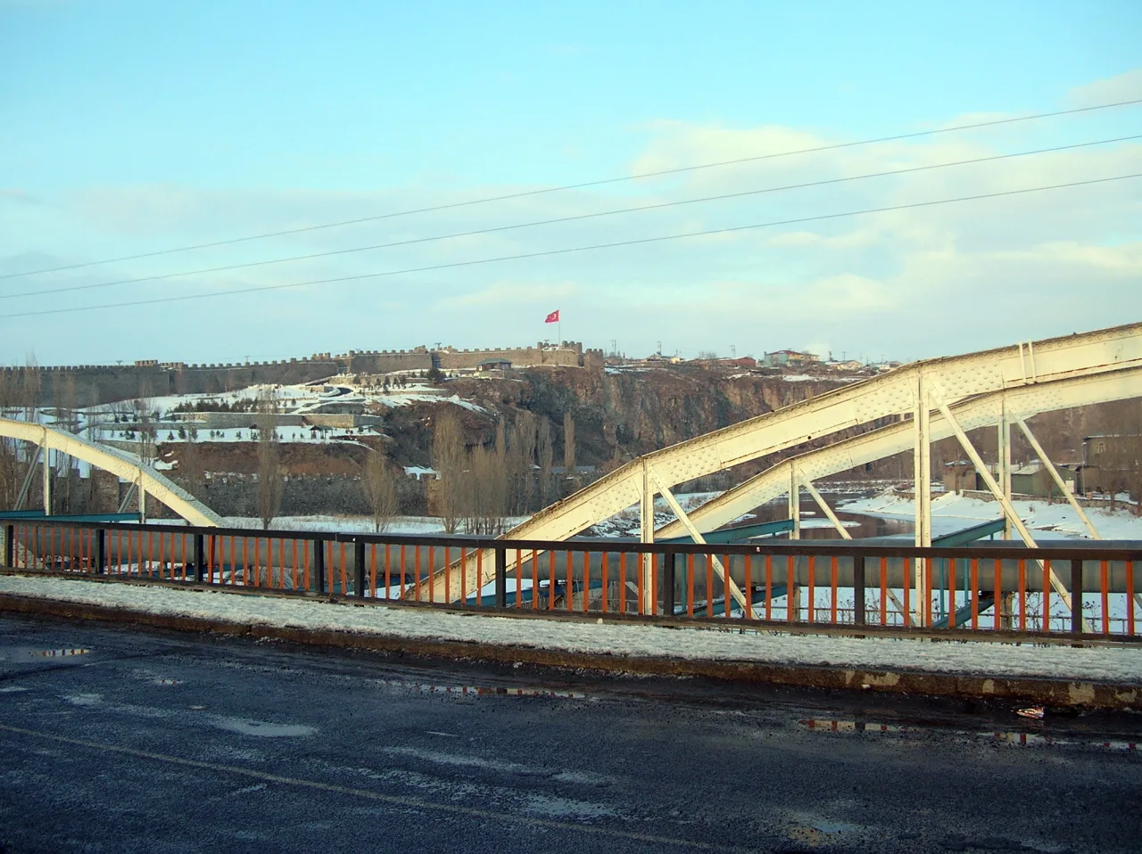
Ardahan Castle and Lake Çıldır are two different waterside landscapes. A city monument and an extensive lake require different preparation, especially in winter.
An AI-assisted synthesis of the sources below, with Atlas planning suggestions. This is not a first-hand visit report. Admission, transport and access conditions must be checked with operators before travel.
In this guide
An inscription and earlier layers
The fortress’s first foundation date is uncertain. Ottoman repairs and the sixteenth-century inscription do not explain its whole past. Read towers, gateway and river position together without assigning every wall to the same period.
Çıldır is more than an ice photograph
Shared by Ardahan and Kars, the freshwater lake also matters for fishing and birds. Winter images do not establish that ice is safe everywhere or on every day. Consider access onto ice only through current official safety and permission information.
A realistic seasonal route
Snow, wind and road conditions can alter the outing. Observation from shore is a complete experience in its own right. Open water, frozen surfaces and changing shorelines are different states of one place, not guaranteed activities in a fixed seasonal package.
The relationship between the town, castle and Kura
Read Ardahan Castle through its position beside the Kura River rather than as an isolated stone monument. Walls, towers and gateways explain defence; water and crossings explain movement around a settlement. Its earliest construction date is uncertain. The inscription of 1544 at the western gate and repairs under Süleyman the Magnificent provide more specific evidence than assigning every surviving part to prehistory or to one dynasty. Finds from earlier settlement around the site do not make the present walls the same age.
On a town walk, give civil buildings and places of worship from other periods separate attention. The congress memory associated with Hamşioğlu Rasim Bey Mansion does not mean that the castle was built for the same meeting. A short programme around the river and a visit to a remote district's castle operate on different scales. A rocky height that looks close on a map can involve a separate approach and walking itinerary.
Çıldır and Aktaş: two lakes with different contexts
Lake Çıldır is shared across Ardahan and Kars. Choosing a particular shore changes the approach route. Images of winter fishing and sledding show livelihoods and visitors meeting on the same water surface, but a picture does not report the ice's ability to carry weight today. Observation from the shore and an activity on the ice should be separate decisions. Do not try to direct fishers' working routines as a tourist performance; ask permission for close observation or filming.
Lake Aktaş is a different wetland shared with Georgia. Its islands and shores matter to birds, although a species' presence is not a promise of a sighting every day. The archaeological setting around Akçakale at Çıldır connects with a lake visit, but not every shore is an unrestricted boating or picnic area. Follow protection signs. A border lake should never be promoted as a casual trip to the opposite shore independent of visa and crossing arrangements.
Damal: an event of light and a cultural memory
At Damal, the silhouette resembling Atatürk's profile is a natural image created by light and shadow on a slope, not an enormous carved portrait. Season and sunset angle matter, but clouds and visibility prevent a promise of the same view every evening. The governorate's 2017 festival record documents observation around Yukarıgündeş; an old ceremony date is not a fixed calendar for a future visit. Reading the phenomenon as a meeting of landscape, perception and Republican memory is more informative than presenting it as a permanent monument.
The Damal doll introduces another kind of heritage. Details of local women's clothing are translated into a small-scale crafted object. Headwear, fabric, colour and ornament carry cultural knowledge rather than functioning only as attractive accessories. Ask who made a doll, which techniques were used and what the clothing elements are called. A souvenir should not imply that an entire community dresses in precisely that way every day.
Build separate district encounters in Göle, Hanak and Posof
The province's six districts comprise the centre, Çıldır, Damal, Göle, Hanak and Posof. Treating these names only as directions conceals the breadth of the rural province. Towards Göle, pasture and livestock offer one perspective; around Hanak, valleys and settlement traces offer another; towards Posof, the border landscape adds a further context. Do not fold the rock-cut spaces around Ortakent and Posof's mosque and castle settings into one village story from a single period.
A village name does not guarantee identical transport and visiting arrangements in every season. Match the correct district, approach and return connection with local information. An old online population table can also mislead if used to describe the scale of a settlement now. Directions from a resident are valuable, but they do not replace permission to enter a workplace, private land or restricted border area. Decide whether the day's focus is settlement history, farming or a landscape rather than attempting all three across several distant districts.
Yalnızçam and the highlands: choose the scope of the activity
Skiing at Yalnızçam, a summer highland walk and a scenic stop around Bülbülan do not require identical equipment or time. Promotional descriptions of ski runs are dated records; check which runs and operations are actually available. A landscape photograph does not map a safe walking line. A visitor wanting a short viewpoint stop needs a different plan from someone intending a lengthy highland traverse.
A yayla is not empty countryside. Grazing, seasonal accommodation and work continue there. Passing through a flock or photographing a temporary dwelling without permission is not an automatic tourist entitlement. Plan the route with these living uses in mind. Preserve a return arrangement in case of changing weather or road conditions. This produces a more meaningful encounter with high ground than an ambitious circuit whose numerous stops leave no time to understand the landscape or the people using it.
Honey, cheese and the table: keep production in the story
Ardahan honey, cheeses and pastries such as kete and feselli connect the table with mountain and pasture landscapes. Asking which producer supplied a food and how it is stored is more instructive than buying a regional name alone. Milk production around Göle and a sales counter in the city represent different stages: milking, processing and transport sit behind the visible product. A place name is not a guarantee of medical benefit or food safety.
Names such as Posof apples and kavılca grain also remind travellers that the province is not only a winter-sports destination. Blossom, harvest and production visits depend on the season. A town visit, one lake and a production or craft encounter give a short journey a coherent structure. For a longer stay, add districts progressively instead of squeezing the provincial list into one day. Time for questions about work, material and season often reveals more than another fleeting stop at a distant viewpoint.
Choose the visit that fits your question
History
Separate foundation from repair dates.
Ecology
Include fish and bird life in the lake’s story.
Winter planning
Do not treat photographs as ice-safety information.
Visual exploration before you travel
Ardahan — official destination film
The film published on 27 February 2017 introduces the province's cultural and natural landscapes. It is not a current notice of ski operation, ice safety, border crossings or festivals.
Kültür ve Turizm Bakanlığı WebTV · Watch the official publication ↗
Practical questions before your visit
Is the Damal silhouette a monument visible every day?
No. It is a seasonal image formed by light and shadow, also affected by weather and visibility. Do not treat it as a carved portrait or a performance guaranteed every evening.
Are Çıldır and Aktaş two names for one lake?
No. Çıldır relates to Ardahan and Kars; Aktaş is a separate lake shared with Georgia. Consider shoreline, conservation and border arrangements separately for each.
Is a ski holiday enough to understand Ardahan?
It reveals one aspect rather than the whole cultural landscape. Town and castle, lakes, Damal craft, district settlements and production culture can anchor different days or interests.
Sources and scope of this guide
These primary sources support the historical and heritage background. Comparisons and suggested ways to organise a visit are Atlas editorial analysis, not instructions from the source institutions.
- Kültür Portalı · ARDAHAN KALESİ ↗
- Kültür Portalı · ÇILDIR GÖLÜ ↗
- GoTürkiye — Ardahan'ın ilçeleri ve kültür durakları ↗
- Ardahan İl Kültür ve Turizm Müdürlüğü — Çıldır Gölü ↗
- Doğa Koruma ve Milli Parklar — Çıldır Gölü ↗
- Kültür Portalı — Damal Bebeği ↗
- Ardahan Valiliği — Damal'da silüet gözlemi ve 2017 festival kaydı ↗
- GoTürkiye — Ardahan mutfağı ↗
- Serhat Kalkınma Ajansı — Ardahan coğrafyası ve ilçeleri ↗
- Kültür ve Turizm Bakanlığı WebTV — Ardahan tanıtım filmi ↗