
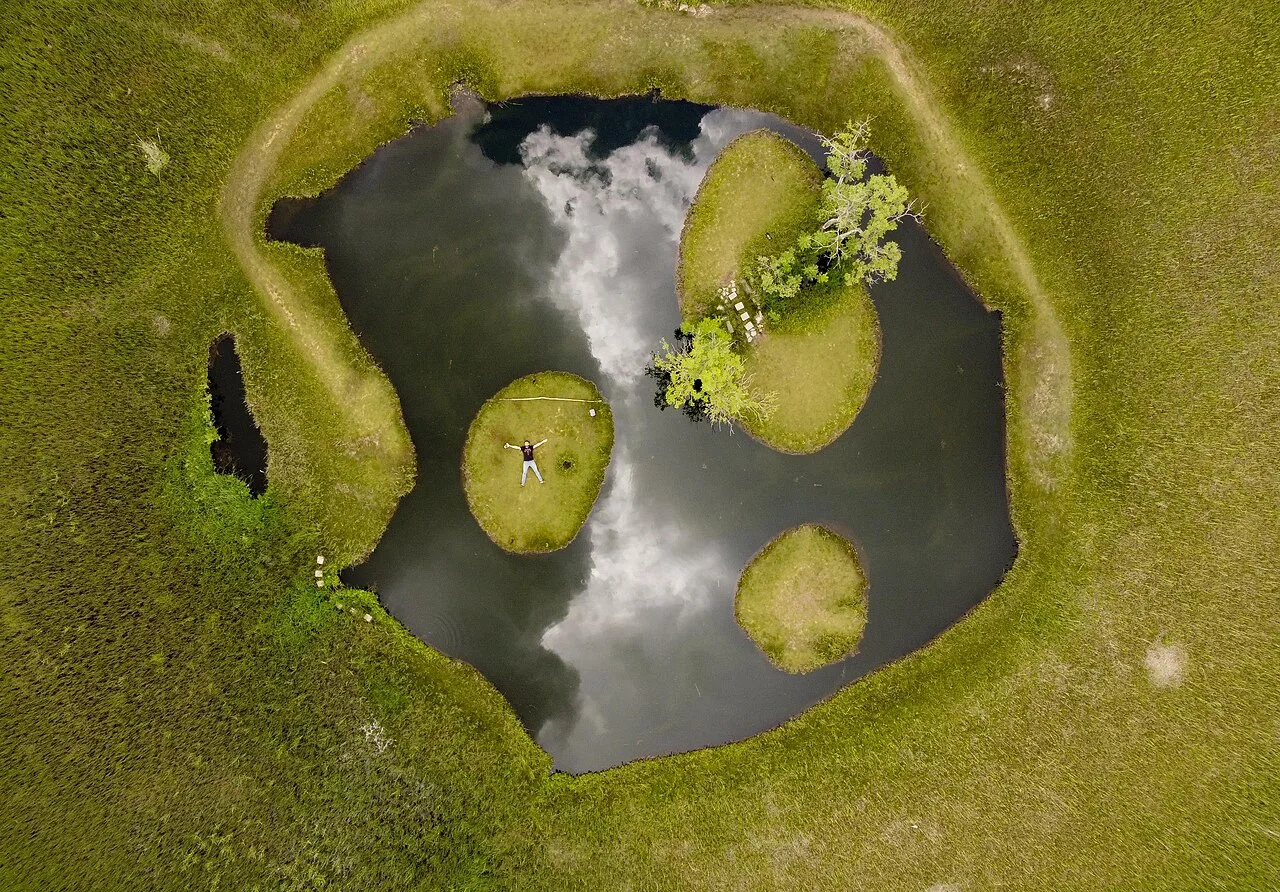
The floating islands near Solhan and the Buban formations around Sancak reveal different natural processes. They are not neighbouring stops in one direction from the provincial centre; plan their journeys separately.
An AI-assisted synthesis of the sources below, with Atlas planning suggestions. This is not a first-hand visit report. Admission, transport and access conditions must be checked with operators before travel.
In this guide
Observe the floating islands
Root-bound vegetation forms mobile islands on Turna Lake. Their ability to move is not an invitation to climb aboard or push them around. From the viewing area, watch the relationship between water, plants and wind without altering the feature you came to see.
Read erosion at Buban
The pointed formations near Oğuldere developed through the erosion of tuff. Differences in resistance, runoff and slope help explain their shapes. Climbing fragile tips can damage them as well as expose visitors to a fall.
Conditions matter more than distance
Check rural road and weather conditions locally instead of assuming a fixed walking time. Stay within designated areas beside the lake and rock formations. A natural-looking setting does not automatically permit swimming or camping. With limited time, one careful visit offers more than two hurried arrivals.
Understanding the Floating Islands as a natural phenomenon
The Floating Islands near Aksakal in Solhan's Hazarşah area are Bingöl's best-known image, but their interest lies in more than an attractive view. Vegetated islets move independently across the water. The National Parks authority records designation as a natural monument in 2003. That protected status is different from the idea of a raft to climb onto for a souvenir photograph. Observing the root-bound surfaces and their relationship with the water from the shore makes the visit an exercise in attention rather than an attempt to consume the spectacle.
Wind and season alter both movement and appearance; the islands will not necessarily occupy the same positions or look equally green on every visit. Viewpoints separate visitors from fragile surfaces while providing a wider perspective. Estimates of lake depth and descriptions of standing on an island in old promotional pages are not current measurements or permission notices. Follow the conservation and visitor-management instructions encountered at the site rather than using an old photograph as an access guide.
Zağ and Buban: human carving and natural erosion
The Zağ rock shelter rooms and Buban formations are not interchangeable rocky photo stops: they illustrate different processes. At Zağ, carved rooms, shelves, seating surfaces and passages point to the deliberate organisation of space. The provincial culture directorate presents historical period attributions cautiously, as interpretations rather than definitive dating for every chamber. Reading the plan, traces of use and subsequent alteration is more informative than attaching an unquestioned Urartian date to the entire complex.
The Buban formations promoted around Oğuldere in the Sancak area are an erosional landscape. Their pointed forms make differences in the way surfaces weather visible. In both places a photogenic rock is not automatically a safe climbing surface. Zağ's narrow, steep approach needs different preparation from a walk on exposed ground around Buban. Respect conservation boundaries, do not scratch the stone and leave fragments where they belong. The distinction between interpreting a site and physically entering it is especially important around vulnerable rock-cut remains.
From the city to Kiğı and the Peri Suyu valley
İsfahan Bey Mosque in central Bingöl provides a useful lesson in the difference between a building's foundation story and the fabric visible today. The provincial architectural record describes a substantial repair in 1918 and damage to the minaret in the 1971 earthquake. It would therefore be misleading to present the whole exterior as an unchanged structure from one early period. Stonework, the minaret base and repairs can reveal change as well as continuity, making the mosque a subject for careful observation rather than a date to memorise.
Kiğı, Bağlarpınarı, Adaklı and the Peri Suyu surroundings are separate rural and historical journeys, not extensions of a central walking route. Mosques, cemeteries, fountains, monastery remains and river landscapes place traces of different communities beside one another. A listed ruin does not guarantee safe interior access or regular opening hours. Arrange transport with current local information and respect worship, private property and privacy in inhabited villages. Giving each area time prevents the province's heritage from becoming a hurried collection of names.
Highland journeys and the actual limits of a season
Hesarek, also written Haserek, is associated with the ski facility around Dikme village; Yolçatı is another winter-sports area. Treating both names as the same establishment can send a journey in the wrong direction. Snow in a photograph is not evidence that pistes, lifts or equipment rental are operating that day. Confirm facility announcements, road conditions and equipment needs together. High ground toward Karlıova likewise involves weather and access conditions different from a short walk in town.
Bingöl's summer pastures are working landscapes for herders and beekeepers, not empty camping scenery. Keep routes clear, allow distance from livestock guardian dogs, and check fire and camping permissions. Hot-water tourism around Kös and Ilıcalar introduces another seasonal experience, but operating arrangements can change and promotional treatment claims should not be read as medical guidance. Nor should old assertions that sunrise can be properly seen in only two places worldwide be repeated as a scientific distinction. A good journey depends on local conditions and responsible preparation, not promotional superlatives.
The table, honey and the province's research life
Sörin, keldoş, löl and mastuva explain different relationships between dough, yoghurt, dried kurut and livestock production in Bingöl's cooking. A shared dish name does not guarantee identical ingredients in every home: fillings in löl can vary, and a kurut-based dish contains dairy. Visitors with allergies or specific dietary requirements should ask the establishment about its recipe. The menu is not merely a checklist of four things to taste, but an opening to discuss preparation, household practice and the labour involved.
Honey is more than a famous souvenir. Bingöl University's announcement of its 2026 beekeeping sector report discusses hives, yields and the regional economy, while distinguishing forecasts from recorded production. Asking about the producer, harvest and traceability is more useful than accepting the word natural as a complete explanation. Education and research also belong to the contemporary city, connecting local production with the landscapes visitors come to see. To regard Bingöl only as a road junction is to overlook a living economy and an institutional culture that continues to investigate it.
Choose the visit that fits your question
Water focus
Watch the islands from shore without interfering.
Geology focus
Relate Buban’s forms to their hillside.
Route choice
Choose one area for a short visit.
Visual exploration before you travel
The Floating Islands: a field report showing their movement
A public video report dated 26 May 2024 showing the islets moving with the wind. It is not a current notice of admission rules or visitor numbers.
TRT Haber / Anadolu Ajansı · Watch the official publication ↗
Bingöl University Faculty of Arts and Sciences
A public institutional film linked by the faculty's official page, giving context to education and research in the living city. It is not a film covering all of the province's attractions.
Practical questions before your visit
May I step onto the Floating Islands?
Do not treat the protected islets as visitor rafts. Historical photographs or promotional descriptions are not permission notices. Observe from the designated shore arrangements and follow current staff instructions to protect the delicate vegetation.
Can Zağ, Solhan and Kiğı form one short excursion?
They involve different district and rural directions. Appearing together on an attractions list does not make them an easy single-day circuit. Allow separate time and return-transport planning for Solhan's islands, Zağ and the Kiğı–Peri Suyu area.
What should I ask when buying local honey?
Ask about the producer, origin, harvest and traceability. A provincial research report explains production patterns; it does not guarantee the properties or health effects of an individual jar. Treat honey as food and local production, not as a promise of medical treatment.
Sources and scope of this guide
These primary sources support the historical and heritage background. Comparisons and suggested ways to organise a visit are Atlas editorial analysis, not instructions from the source institutions.
- Kültür Portalı · YÜZEN ADA ↗
- Kültür Portalı · BUBAN PERİBACALARI ↗
- DKMP XIII. Bölge — Yüzen Adalar Tabiat Anıtı ↗
- Bingöl İl Kültür ve Turizm Müdürlüğü — mağaralar ve Zağ ↗
- Bingöl İl Kültür ve Turizm Müdürlüğü — tarihî camiler ↗
- Bingöl İl Kültür ve Turizm Müdürlüğü — Haserek Kayak Merkezi ↗
- GoTürkiye — Bingöl ilçe ve doğa rotaları ↗
- GoTürkiye — Bingöl mutfağı ↗
- Bingöl Üniversitesi — 2026 Arıcılık Sektör Raporu duyurusu ↗
- TRT Haber / AA — Yüzen Adalar saha görüntüleri, 26 Mayıs 2024 ↗
- Bingöl Üniversitesi Fen Edebiyat Fakültesi — tanıtım ve bölümler ↗