Independent Türkiye discovery and reference guide

Cumhuriyet Atlas

Cumhuriyet Atlas · Regional dossier

Southeastern Anatolia: cities, culture and paths to explore

Explore Southeastern Anatolia without reducing it to one prescribed itinerary: move through provinces, official visitor records, verified heritage properties and sourced place photographs.

Go to the city directory
Stone enclosure, T-shaped pillars and modern protection at Göbeklitepe Building F
Göbeklitepe Building F · a place in Southeastern Anatolia

22 September 2019: the stone enclosure, pillars and modern protection at Göbeklitepe Building F in Şanlıurfa. It does not depict the whole excavation or today's visitor route.

Photograph date: 2019-09-22

Dosseman / Wikimedia Commons · DICK OSSEMAN

Göbeklitepe Building F 5366.jpg · CC BY-SA 4.0

The existing source JPEG's whole frame is retained. The existing 1280-pixel WebP conversion is used for display; the site adds no crop, retouch or synthetic content.

This photograph is shared under its stated Creative Commons licence; the site-wide copyright notice imposes no additional reuse restrictions on this photograph.

Province directory
9
Official place records
104
UNESCO properties
3
Photographs and video
3

Southeastern Anatolia: turn large historical claims into specific observations

Before calling something the first or the oldest, ask what is being compared. Our Şanlıurfa guide distinguishes visible evidence at Göbekli Tepe from its interpretation. The approach is useful elsewhere: what does a label establish, what is an interpretation offered by researchers, and what conclusion are you drawing yourself? A meaningful visit can connect all three without pretending that they are the same kind of statement.

Do not automatically treat a city museum and an archaeological site as competing stops. One may help explain objects and evidence, the other the scale of a settlement; reaching both need not be the only measure of a successful day. Allow time for transport, outdoor rest and the return journey. Provinces in this directory are grouped for browsing, not as a transport sequence. Choose the next stop by the question left by the previous visit rather than by the desire to repeat a similar view.

Atlas planning desk · Published by Webz Fusion. These are editorial decision aids, not bookings, live quotations or first-hand reviews.
Read a focused destination guide

World Heritage

UNESCO records in Southeastern Anatolia

The year, type and official link on each card come from the UNESCO World Heritage Centre record.

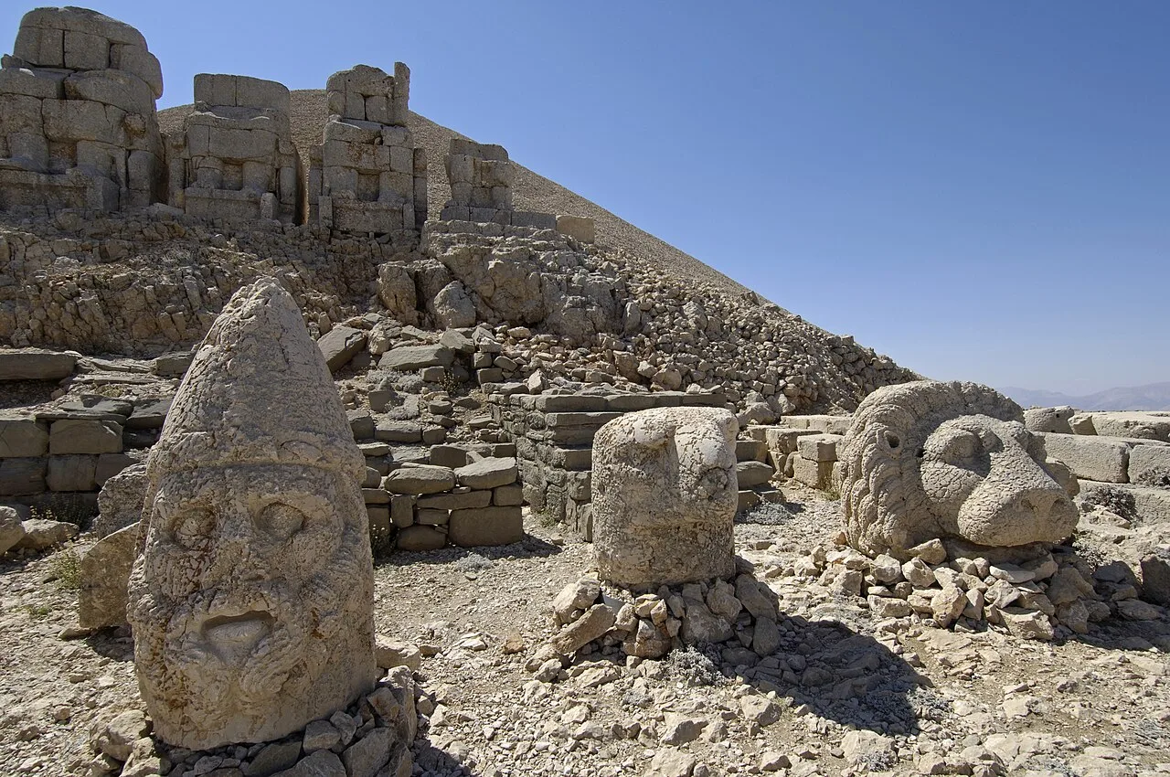
Sculptural heads, an eagle and a lion before stone statue bodies on Nemrut's east terrace

1987 · Cultural heritage

Nemrut Dağ

A cultural heritage property inscribed on the UNESCO World Heritage List in 1987.

Explore the province guide → Verify in the official record ↗
Photograph and rights

Nemrut's east terrace photographed by Dosseman on 12 September 2006. The dated image helps relate sculptural heads to statue bodies; it does not establish today's conservation arrangement or seasonal road access.

Dosseman / Wikimedia Commons; reduced-resolution Commons rendition · CC BY-SA 4.0 ↗

Image archive record ↗
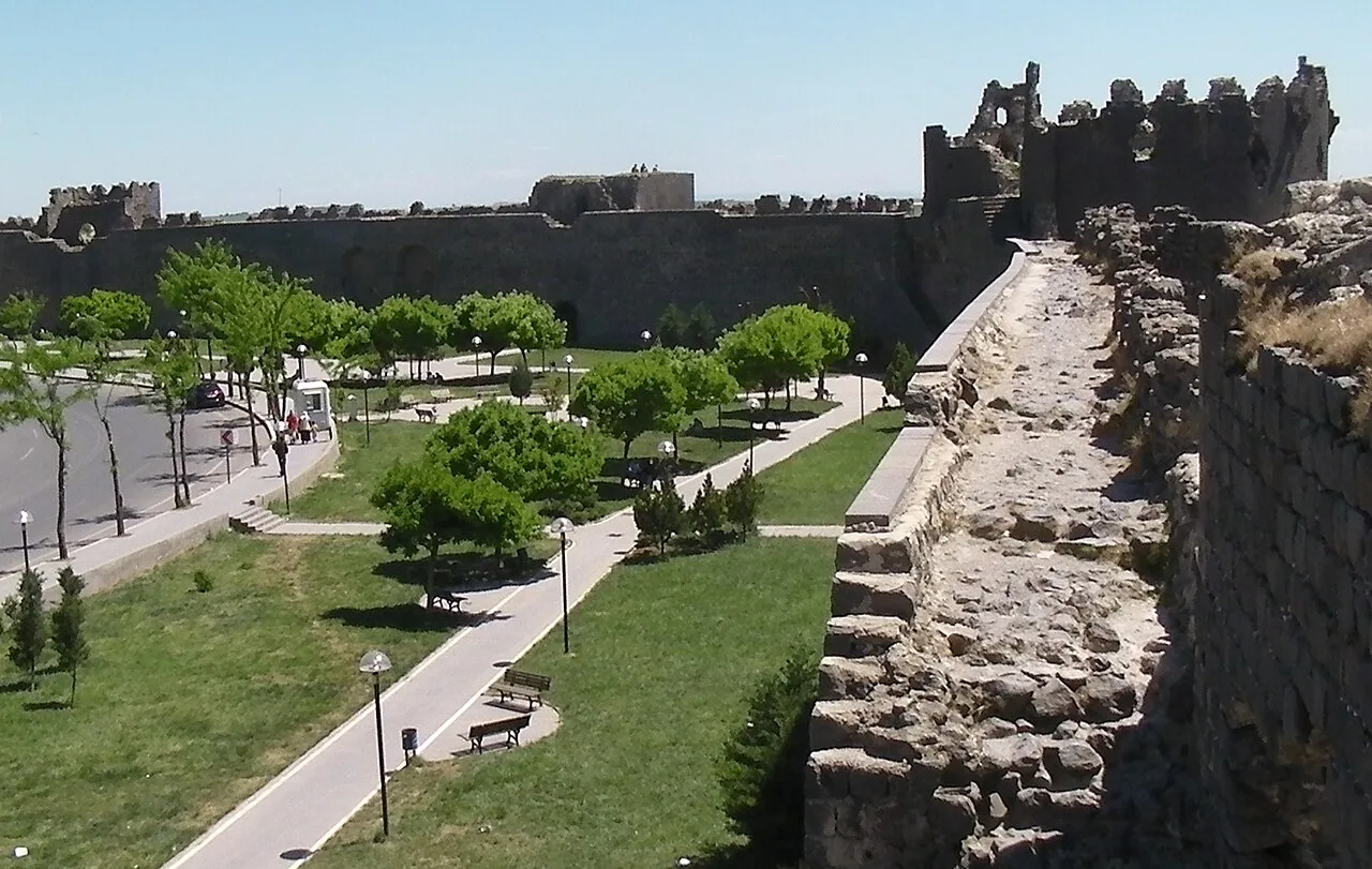
Walls, towers and a green space seen from inside Diyarbakır's fortifications

2015 · Cultural heritage

Diyarbakır Fortress and Hevsel Gardens Cultural Landscape

A cultural heritage property inscribed on the UNESCO World Heritage List in 2015.

Explore the province guide → Verify in the official record ↗
Photograph and rights

An interior view of the fortifications photographed by Brian Dell on 25 April 2010. This dated archive photograph does not establish present permission or safety for walking on the walls; use only open, authorised visiting routes.

Brian Dell / Wikimedia Commons; reduced-resolution Commons rendition · Public domain — released by the photographer ↗

Image archive record ↗
Stone walls and pillars in Building F at Göbeklitepe

2018 · Cultural heritage

Göbekli Tepe

A cultural heritage property inscribed on the UNESCO World Heritage List in 2018.

Explore the province guide → Verify in the official record ↗
Photograph and rights

Building F at Göbeklitepe, photographed by Dosseman on 22 September 2019. This is a dated view of a specific structure, not a view of the entire excavation or a statement about today's visitor route.

Dosseman / Wikimedia Commons; original published image · CC BY-SA 4.0 ↗

Image archive record ↗

Motion Atlas

Southeastern Anatolia visual routes

Silent videos made from AI-generated regional illustrations are not documentary footage; they never autoplay and use a local player with accessible captions.

From Highlands to MesopotamiaA silent visual route assembled from two original Atlas illustrations of the Black Sea and Southeastern Anatolia.7.2 seconds · Cumhuriyet Atlas / original generated visual sequence
From Mesopotamia to the HeartlandA silent visual route assembled from two original Atlas illustrations of Southeastern and Central Anatolia.7 seconds · Cumhuriyet Atlas / original generated visual sequence